AVeReS Project
AVeReS is an acronym for:
Assessment of Vegetation damages using Remote Sensing
The AVeReS is a project granted by The European Space Agency (ESA Contract No: 4000107684/13/NL/KML, 192600-62-388), devoted to assessment of the potential of satellite data for analysis and monitoring of vegetation with a special focus on vegetation mapping and condition investigation. We propose a study of vegetation based on Landsat and WorldViev-2 imagery analysis supported by a range of field remote sensing techniques and laboratory measurements within plant physiology. The following techniques will be employed:
- hyperspectral field data acquisition (radiometric measurements, construction of spectral libraries of dominant vegetation communities using satellite imagery and field measurements),
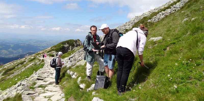
- investigation of plant condition using remote sensing field techniques and supportive techniques within plant physiology (including measurements of LAI, fAPAR, plant biometric properties, plant pigments content, fluorescence, fresh and dry biomass, plant and soil humidity, plant transpiration and evapotranspiration, soil-vegetation-atmosphere heat exchange),
- GPS localisation,
- analysis of microclimate conditions (sun radiation; air and soil temperature and humidity, TIR),
- image classification,
- integration of field and satellite data.
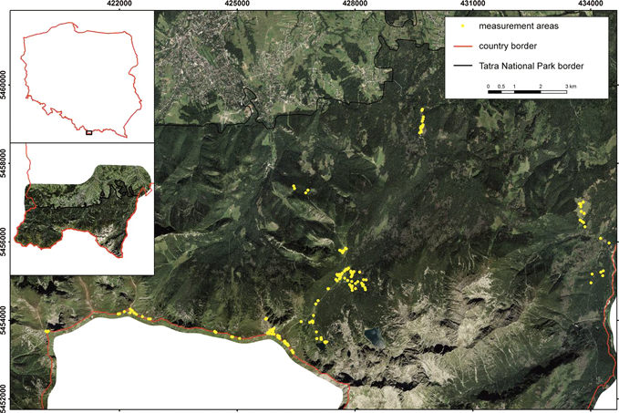
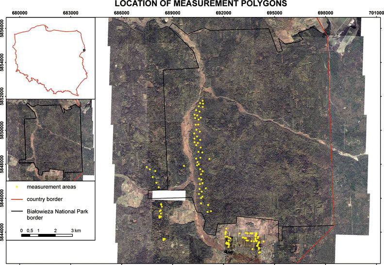
Information about the vegetation condition is needed for effective management of the natural resources and estimation of the effectiveness of nature conservation. Vegetation condition assessment is based on information about quality of plant pigments, cell structure and plant’s vigour and indices, which are dedicated to analyse the plant condition. During the researches the most valuable natural areas in Poland will be analysed (the Tatra National Park – TPN and Bialowieza Forest – BF, both are the M&B Reserves). Monitoring and early warning about bad condition of the plants is very important to minimize negative effects not only on protected areas. BNP and BF are good test polygons, because there is different level of anthropogenic impact on the environment (strict natural preserve and forestry), different damage (gradations of insects, windthrows, air pollution, changes in groundwater level). The validated algorithm and satellite images could be supporting tools for long-term monitoring on different types of vegetation and different topographic situations as well.
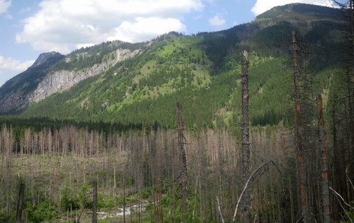
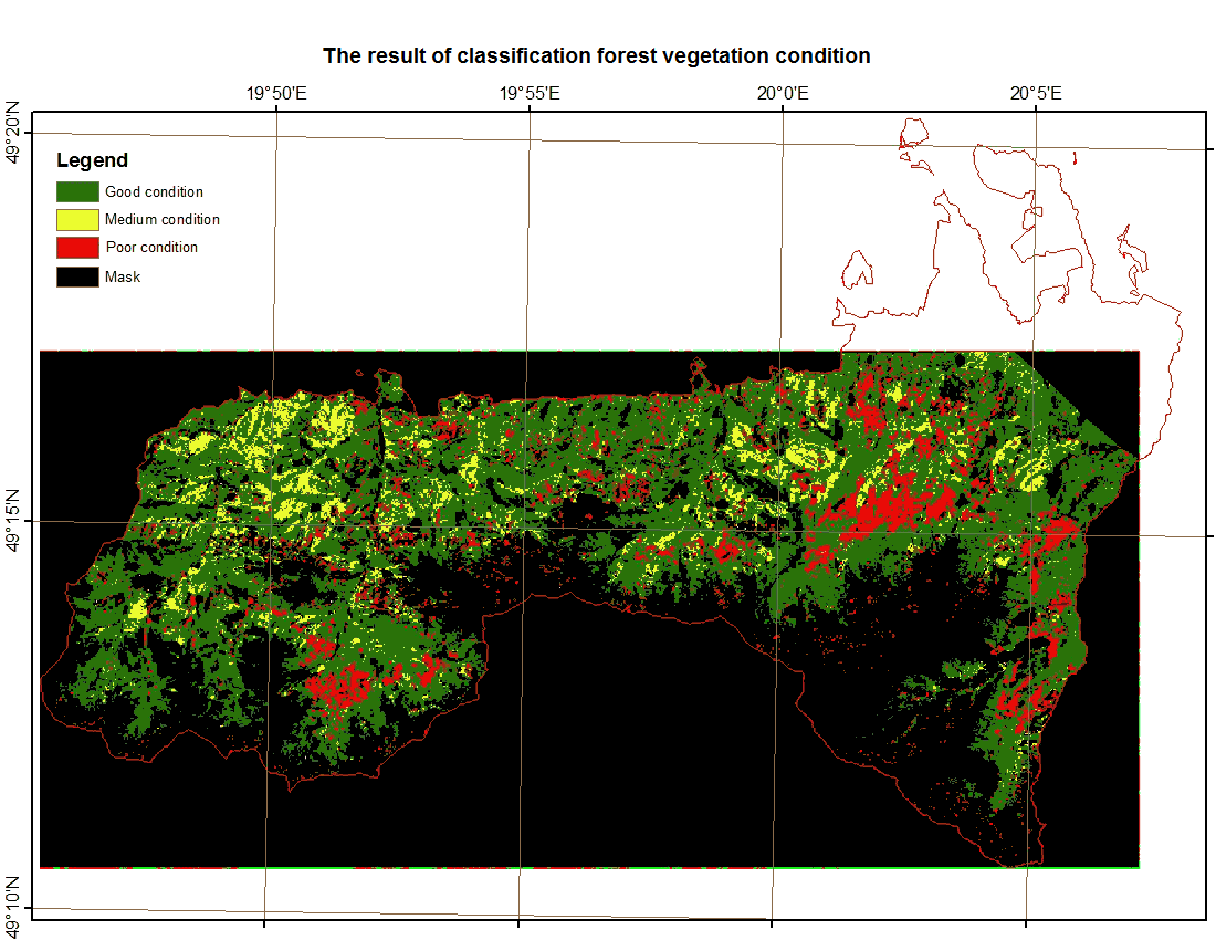
Damaged forest in Tatra Mountains
Specific scientific objectives:
- Evaluate the usefulness of satellite data for analysing the plant damages in different ecosystems,
- Develop an universal algorithm, that uses spectral properties and also structural features of the image,
- Identification of remote sensing indices, that are well correlated with vegetation parameters acquired from ground levels,
- Compare the usefulness of remote sensing data with different spatial and spectral resolution (comparing Landsat and WorldView-2),
- Explore possibilities of collecting information about individual trees in the forest with/or no pansharpened WorldView-2 image,
- Classification of damaged plants using various algorithm
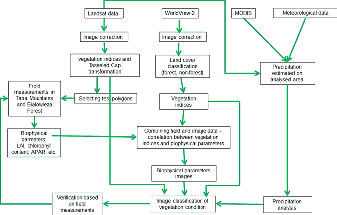
Work Packages
WP1: Management and reporting (03.2013–05.2013)
WP2: Proposed demonstration plan (03.2013–05.2013)
WP3: State of the art (03.2013–07.2013)
WP4: Field campaign plan (03.2013–05.2013, 03.2014–06.2014)
WP5: Field experiment (04.2013–08.2013, 04.2013–08.2013)
WP6: Image processing (05.2013–04.2014)
WP7: Algorithm optimalisation (12.2013–11.2014)
WP8: Dissemination of results (09.2014–02.2015)
Team
Assoc. Prof. Bogdan Zagajewski – Project coordinator
Dr. Malgorzata Krowczynska – Project manager, Data quality manager
Dr. Anna Jarocińska – Image processing coordinator
Dr. Piotr Pabjanek – Field campaign coordinator
M.Sc. Adrian Ochtyra – Field data coordinator
M.Sc. Prakash Madhav Nimbalkar – Ph.D. student
MSc. Karolina Orłowska – Ph.D. student
MSc. Ewa Wilk – Ph.D. student
M.Sc. Adriana Marcinkowska-Ochtyra – Ph.D. student
M.Sc. Marlena Kycko – Ph.D. student
Ania Chlebicka – M.Sc. student
Selamawit Yetemegn – M.Sc. student
Presentations
- M. Kycko, B. Zagajewski, A. Kozlowska, A. Ochtyra, A. Marcinkowska, Variability of spectral characteristics of trampled high mountain meadows of the Tatra National Park and M&B Reserve. 33. EARSeL Symposium „Towards Horizon 2020: Earth Observation and Social Perspectives”, 3-6 June 2013, Matera, Italy (oral presentations).
- A. Ochtyra, B. Zagajewski, A. Kozlowska, A. Marcinkowska, P. Gamba, M. Kycko, A. Jarocinska, Mapping of damaged forest areas of the Tatra Mountains using Landsat images and fuzzy ARTMAPsimulator. 33. EARSeL Symposium „Towards Horizon 2020: Earth Observation and Social Perspectives”, 3-6 June 2013, Matera, Italy (oral presentations).
- S. Yetemegn, B. Zagajewski, P. Pabjanek, Analysis of protected and unprotected zones of the Bialowieza Primary Forest (NE Poland). 33. EARSeL Symposium „Towards Horizon 2020: Earth Observation and Social Perspectives”, 3-6 June 2013, Matera, Italy (poster).
- M. Kycko Marlena, B. Zagajewski, A. Ochtyra, A. Modzelewska, Cechy spektralne dominujących gatunków muraw wysokogórskich Tatr [The spectral characteristics of the dominant species in the high mountain grasslands of Tatras], 7. Polish Symposium on Geoinformatics, 11-13 September 2013, Warsaw (oral presentations).
- A. Modzelewska, A. Jarocińska, M. Kycko, A. Ochtyra, B. Zagajewski, Kondycja roślinności Czerwonych Wierchów [Vegetation Condition in Czerwone Wierchy, Tatra Mountains]. 7. Polish Symposium on Geoinformatics, 11-13 September 2013, Warsaw (oral presentations).
- A. Ochtyra, B. Zagajewski, A. Marcinkowska, M. Kycko, Analiza kondycji drzewostanów świerkowych Tatrzańskiego Parku Narodowego [Analysis of the condition of spruce stands in Tatra National Park]. 7. Polish Symposium on Geoinformatics, 11-13 September 2013, Warsaw (oral presentations).
- M. Kycko, B. Zagajewski, E. Romanowska, A. Ochtyra, A. Jarocinska, A. Modzelewska, Relationships between narrow-band vegetation indices and fluorescence. 34. EARSeL Symposium, 16-20 June 2014, Warsaw, Poland (oral presentations).
- A. Ochtyra, B. Zagajewski, A. Kozłowska, M. Kycko, A. Jarocinska, A. Marcinkowska, Classification of vegetation damage using Landsat data and Artificial Neural Network. 34. EARSeL Symposium, 16-20 June 2014, Warsaw, Poland (oral presentations).
- A. M. Jarocinska, B. Zagajewski, A. Ochtyra, A. Marcinkowska, L. Kupkova, PROSAIL model in simulating the reflectance of mountains non-forest communities. 34. EARSeL Symposium, 16-20 June 2014, Warsaw, Poland (oral presentations).
- A. A. Faris, A. H. al-Sulttani, A. Ochtyra, A. M. Jarocinska, A. Marcinkowska, Utilization of SEBAL algorithm and Landsat-8 data for estimation of evapotranspiration – a case study: Tatra mountains region. 34. EARSeL Symposium, 16-20 June 2014, Warsaw, Poland (poster).
- M. Kycko, B. Zagajewski, A. Ochtyra, A. Jarocinska, A. Marcinkowska, M. Krowczynska, K. Orłowska, Assessment of WorldView-2 images for condition analysis of trampled high-mountain meadows. 34. EARSeL Symposium, 16-20 June 2014, Warsaw, Poland (poster).
- A. Ochtyra, M. Kycko, A. Jarocinska, B. Zagajewski, P. Pabjanek, M. Krowczynska, A. Chlebicka, The relationship between the amount of precipitation and values of vegetation indices based on Landsat images. 34. EARSeL Symposium, 16-20. June 2014, Warsaw, Poland (poster).
- B. Zagajewski, A. Marcinkowska, E. Raczko, A. Jarocińska, A. Ochtyra, M. Zwijacz-Kozica, T. Zwijacz-Kozica, L. Przewoźnik, M. Dobrowolski, L. Kupkova, P. Stych, Imaging spectroscopy and artificial neural networks in classification of mountain plant communities of protected areas. International Geographical Union Regional Conference „Changes, Challenges, Responsibility”, 18-22 August 2014, Kraków, Poland (oral presentations).
Education and training
1. Field course for students of the Inter-Faculty Studies in Environmental Protection, University of Warsaw
2. PhD:
– Adrian Ochtyra, Assessment of suitability of remote sensing for vegetation damage monitoring in Tatras
– Marlena Kycko, Remote sensing assessment of the condition of the high mountain grasslands exposed to trampling on the example of the Tatra National Park
3. Master Thesis:
– Anna Chlebicka
– Aneta Modzelewska, The vegetation analysis of Western Tatras based on remote sensing data
– Selamawit Yetemegn, 2013, Remote sensing analysis of the vegetation condition of the Białowieza Forest. University of Warsaw, Inter-Faculty Studies in Environmental Protection, Warsaw, pp. 79. MSc. thesis written under the supervision of Dr. hab. Bogdan Zagajewski, Dr. Piotr Pabjanek.
4. Bachelor Thesis:
– Magdalena Michalak, The relationship between precipitation and vegetation indices
5. Erasmus students
Collaborations
- Tatra National Park
- Białowieża National Park
- Assoc. Prof. Anna Kozlowska – Institute of Geography and Spatial Management of Polish Academy of Sciences
- M.Sc. Jakub Bubnicki – Mammal Research Institute of Polish Academy of Sciences
Contact Us
Assoc. Prof. Bogdan Zagajewski – Project coordinator tel: +48 22 5520654 bogdan@uw.edu.pl University of Warsaw Faculty of Geography and Regional Studies Department of Geoinformatics and Remote Sensing (WURSEL)
Dr. Malgorzata Krowczynska – Project manager tel: +48 22 5520654 mkrowczynska@uw.edu.pl University of Warsaw Faculty of Geography and Regional Studies Department of Geoinformatics and Remote Sensing (WURSEL)
ESA PECS Programme Manager: Mr. Bernard Zufferey Mrs. Karine Magne-Lie ESTEC Keplerlaan 1, PO Box 299 NL-2200 AG Noordwijk, The Netherlands karine.magne-lie@esa.int | www.esa.int T +31 71 565 8351 | F +31 71 565 5773
