E-learning course on Time Series Analysis in Remote Sensing for Understanding Human-Environment Interactions (E-TRAINEE) Earth observation data has been acquired for decades, first primarily from satellite and airborne levels and now also from lower altitudes using Unmanned Aerial Vehicles. Archives of such data continue to grow in size with new projects and missions. Volumes of geospatial databases and the number of variables collected by different sensors put them in the Big Data category. Many of them, like parts of NASA or ESA collections, are publicly available, which enables undertaking multi-temporal complex analyses of the Earth surface in terms of quantity, quality, and spatio-temporal characteristics. Knowledge of the ability to access such data, as well as to process and analyze them, is becoming an integral tool that every Earth scientist should possess.

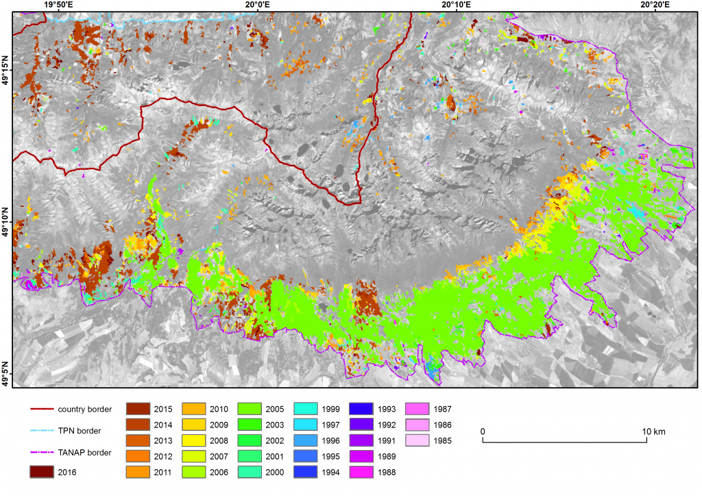
Forest disturbance map in Tatra Mountains based on Landsat time series data (Ochtyra et al., 2020)
The project’s objective is to develop a comprehensive research-oriented open e-learning course on time series analysis in remote sensing for environmental monitoring beyond the existing partners’ curricula. The course offers a multidisciplinary approach connecting themes from computer science, geography, and environmental studies. It combines well established and latest technologies of remote sensing (satellite and UAV sensing, multispectral and hyperspectral sensing, 3D point clouds) and methods of artificial intelligence (machine and deep learning) in order to use these technological developments to understand environmental changes and interaction of human activities and environment. It shows how the same environmental phenomenon can be analysed from the perspective of different data sources, scales and time frequencies. Moreover, it increases students’ digital literacy in time series analysis in remote sensing, which comprises the improvement in methodological and practical data handling skills. The students also gain the skills for critical reflection and communication of complex data processing tasks, enabling them for transformative and interdisciplinary research missions.
The e-learning course consists of four modules. The first one provides a general overview on methods for time series analysis and the three others focus on specific processing steps connected to different types of data and their use in case studies on environmental monitoring:
- Methods of Time Series Analysis in Remote Sensing (leading partner: University of Innsbruck, IU)
- Satellite Multispectral Images Time Series Analysis (leading partner: University of Warsaw, UW)
- 3D/4D Geographic Point Cloud Time Series Analysis (leading partner: Heidelberg University, HU)
- Airborne Imaging Spectroscopy Time Series Analysis (leading partner: Charles University, CU)
Coordinator: CU (Dr. Markéta Potůčková, Department of Applied Geoinformatics and Cartography)
Partner Organisations: HU (Prof. Dr. Bernhard Höfle, Institute of Geography), UW (Dr. Adriana Marcinkowska-Ochtyra, Chair of Geomatics and Information Systems), IU (Dr. Martin Rutzinger, Institute of Geography)
UW members: Dr. Adriana Marcinkowska-Ochtyra, Dr Adrian Ochtyra, MSc Krzysztof Gryguc
Project duration: 01.09.2020-31.08.2023
Course and Data:
The e-learning course on Time Series Analysis in Remote Sensing for Understanding Human-Environment Interactions is available from the course website. It was developed as a GitHub project. Datasets used in the projects are hosted on Zenodo.
Presentations:
Anders K., Höfle B., Zumstein S., Dvořák J., Gryguc K., Kupková L., Marcinkowska-Ochtyra A., Mayr A., Ochtyra A., Potůčková M., Rutzinger M., Time Series Analysis of 3D/4D Point Clouds within the Open-Source Online Course E-TRAINEE, 5th Virtual Geoscience Conference, 20-22.09.2023, Dresden, Germany
Potůčková M., Albrechtová J., Anders K., Červená L., Dvořák J., Gryguc K., Höfle B., Hunt L., Lhotáková Z., Marcinkowska-Ochtyra A., Mayr A., Neuwirthová E., Ochtyra A., Rutzinger M., Šedová A., Šrollerů A., Kupková L., E-TRAINEE: Open e-learning course on time series analysis in remote sensing, ISPRS Geospatial Week, 2-7 September 2023, Cairo, Egypt (poster)
Potůčková M., Albrechtová J., Červená L., Dvořák J., Kupková L., Lhotáková Z., Neuwirthová E., Šrollerů A., Anders K., Höfle B., Mayr A., Rutzinger M., Marcinkowska-Ochtyra A., Ochtyra A., Gryguc K., E-learning on time series analysis in remote sensing: the way towards collaborative course development, 42nd EARSeL Symposium, 3-6 July 2023, Bucharest, Romania
Marcinkowska-Ochtyra A., Albrechtová J., Anders K., Červená L., Gryguc K., Höfle B., Kupková L., Lhotáková Z., Mayr A., Ochtyra A., Potůčková M., Rutzinger M., Wykorzystanie serii czasowych danych teledetekcyjnych w celu zrozumienia interakcji człowiek-środowisko – nowy kurs e-learningowy E-TRAINEE, XXV Ogólnopolska Konferencja Fotointerpretacji I Teledetekcji, 28-30.11.22 (online).
Marcinkowska-Ochtyra A., Albrechtová J., Anders K., Červená L., Gryguc K., Höfle B., Kupková L., Lhotáková Z., Mayr A., Ochtyra A., Potůčková M., Rutzinger M., Understanding human-environment interaction – new e-learning E-TRAINEE course based on remote sensing time series data (original title: Zrozumieć interakcję człowiek-środowisko – nowy kurs e-learningowy E-TRAINEE oparty na seriach czasowych danych teledetekcyjnych), GIS Day 2022 – GIS w stolicy, 23.11.22, Warsaw, Poland
Rutzinger M., Albrechtová J., Anders K., Červená L., Gryguc K., Höfle B., Kupková L., Lhotáková Z., Marcinkowska-Ochtyra A., Mayr A., Ochtyra A., and Potůčková M. E-learning on Time Series Analysis in Remote Sensing and Geoinformatics for Understanding Human-Environment Interactions – a concept”, In: 15. Jahrestagung AK Hochschullehre Geographie – Digital Lehren und Lernen, 2021, Austria


